

")
Current Snapshot
For all the latest updates visit: DisasterAWARE
29s
29S_140600sair
himawari9_ir_29S_202504141310_lat-14.0-lon122.9
29S_tracks_latest
30p

30P_141200sair
30P_tracks_latest
By PDC’s Senior Weather
Specialist Glenn James

The Pacific Disaster Center’s (PDC Global) Monday, April 14, 2025, Tropical Cyclone Activity Report…for the Pacific Ocean, the Indian Ocean, and adjacent Seas
Current Tropical Cyclones:
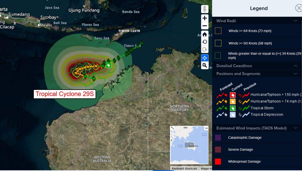
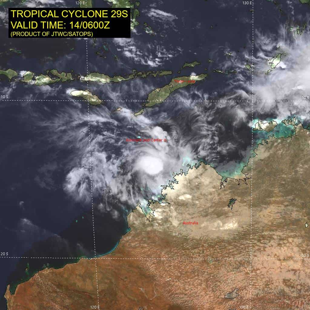
Tropical Cyclone 29S…is located approximately 246 NM north of Broome, Australia
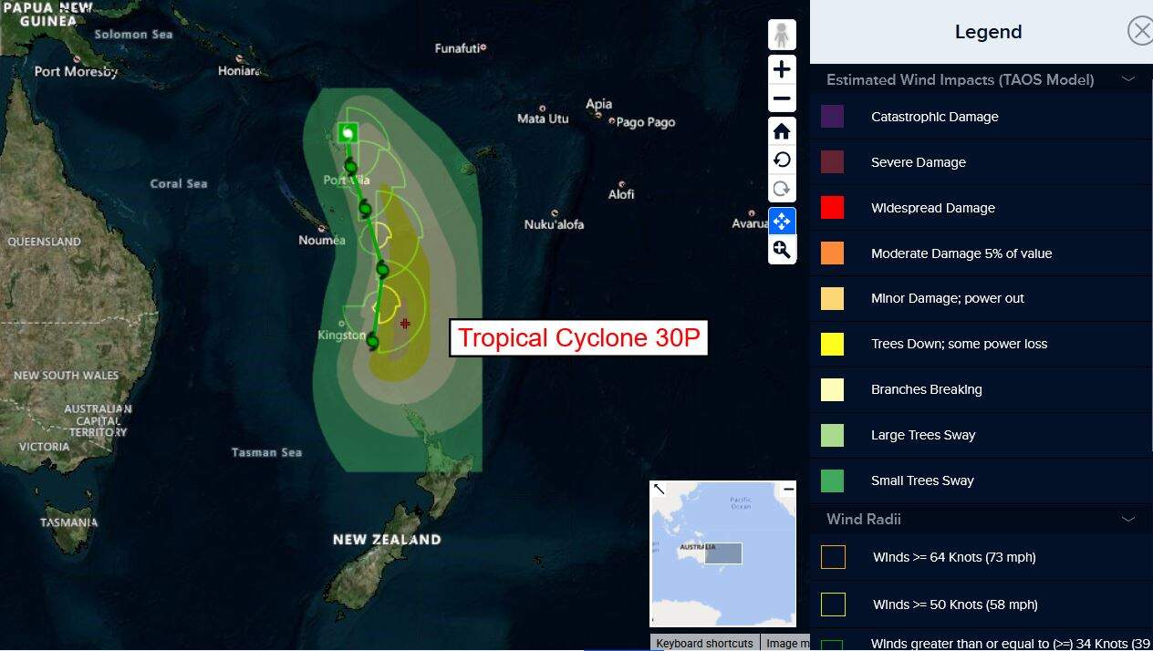
Tropical Cyclone 30P…is located approximately 108 NM southeast of Port Vila, Vanuatu
Northeast Pacific Ocean: There are no Tropical Cyclones
The last regularly scheduled Tropical Cyclone Activity Report of the 2024 eastern North Pacific Hurricane Season has been issued. Routine issuance of this section of the PDC product will resume on May 15, 2025. During the off-season, Special Tropical Weather Outlooks will be issued as conditions warrant by the NHC.
Central Pacific Ocean: There are no Tropical Cyclones
The 2024 central North Pacific hurricane season has ended. As such, the final routine Tropical Cyclone Activity Report for the 2024 season has been issued. Routine issuance of this section of the PDC product will resume on June 1, 2025. During the off-season, Special Tropical Weather Outlooks will be issued as conditions warrant by the CPHC.
Western Pacific, Indian Ocean, and adjacent Seas:
South Indian Ocean
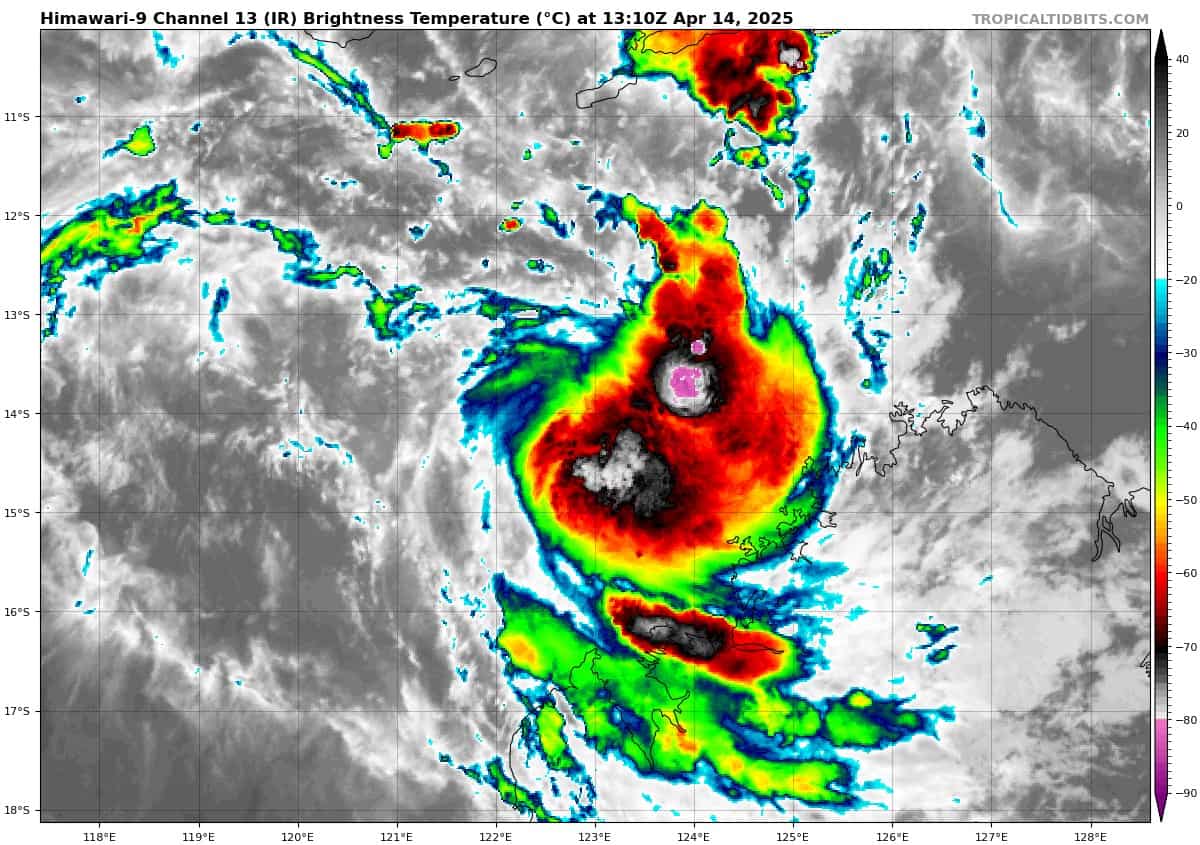
Tropical Cyclone 29S
According to the JTWC Warning number 14, sustained winds are 45 knots, with gusts to 55 knots.
Animated multi-spectral satellite imagery (msi) depicts tropical cyclone 29S with a more compact core of central convection and a low-level circulation center (llcc) that is quickly consolidating over the past 4 hours or so. A microwave image revealed the low-level clouds beginning to tightly wrap into the center with deep convection displaced about 35 NM to the east.
Environmental analysis indicates that 29S is in a favorable environment characterized by moderate poleward and equatorward outflow, low (5-10 knot) vertical wind shear, and warm sea surface temperatures.
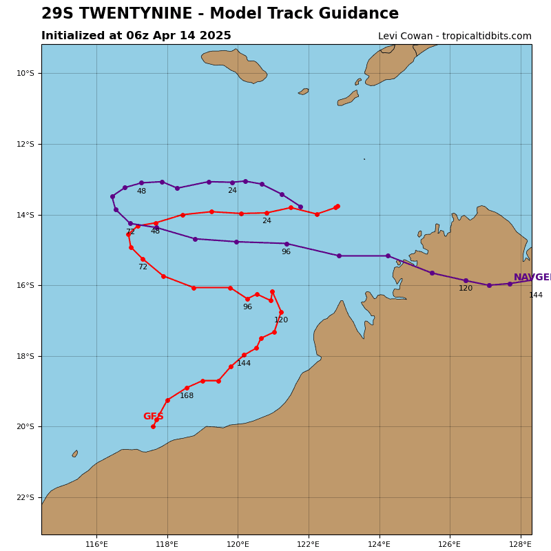
TC 29S is forecast to track generally westward through 48 hours. Near 48 hours, a long wave trough will break down the ridge and cause 29S to come to a halt and begin a sharp east-southeastward turn. 29S will continue to track in the east-southeastward direction through the remainder of the forecast period.
Regarding intensity, TC 29S is forecast to rapidly intensify over the next 48 hours to a peak of 105 knotx, due to the expected highly favorable environment. Shear is forecast to remain below 10 knotx and outflow will become strong. Near 48 hours, westerly shear is expected to begin quickly rising with values near 20 knots at 72 hours, 35 knots at 96 hours, and 45 knots at 120 knots. These high shear values, along with increasing dry air entrainment from the west, will cause 29S to rapidly weaken through 120 hours as the system tracks back toward the coast of Australia.
Southwest Pacific Ocean
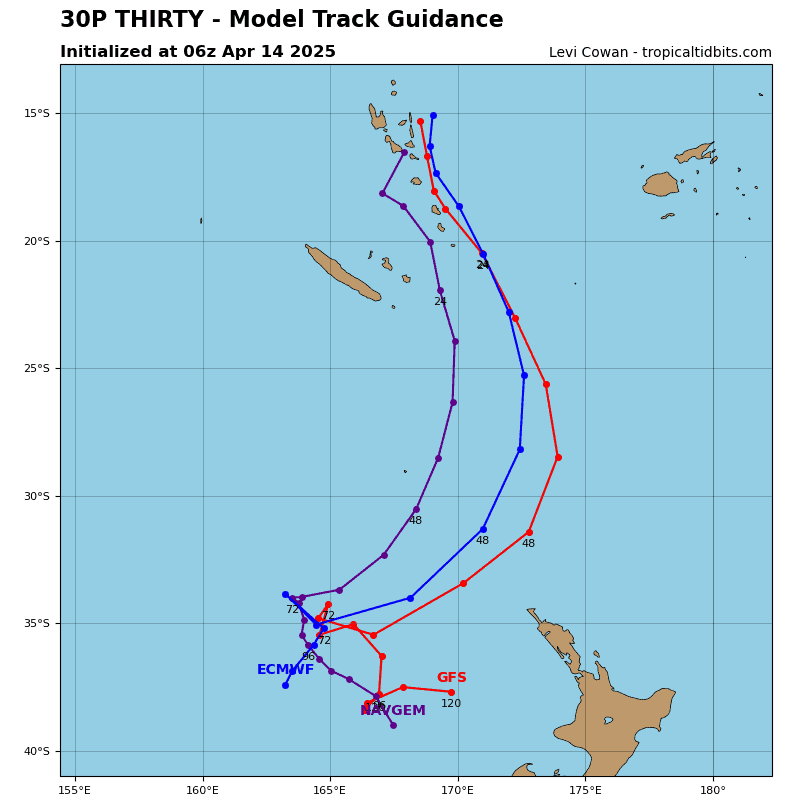
Tropical Cyclone 30P
According to the JTWC Warning number 4, sustained winds are 45 knots, with gusts to 55 knots.
Animated multi-spectral satellite imagery (msi) depicts tropical cyclone 30P with a broad and asymmetrical wind field comprised of the strongest winds confined to the eastern semicircle. Large swaths of convection are now obscuring the circulation center. A microwave image revealed the broad convective banding placed within the northern and southern peripheries of the system.
Environmental analysis indicates that 30P is in a favorable environment characterized by strong poleward and equatorward outflow aloft, low (10-15 knot) vertical wind shear, and warm sea surface temperatures. The main hindering factor for the system will be the asymmetrical and broad wind field.
TC 30P is forecast to track southward, along the western periphery of the str throughout the forecast period with faster than average track speeds. The system is expected to steadily intensify over the next 48 hours due to the favorable environment, particularly poleward outflow.
Near 48 hours, an incoming long wave trough will envelop the system and cause the system to complete subtropical transition by 48 hours and extratropical transition by 72 hours. The cold-core low will then become stationary placed to the northwest of New Zealand.