

")
Current Snapshot
For all the latest updates visit: DisasterAWARE
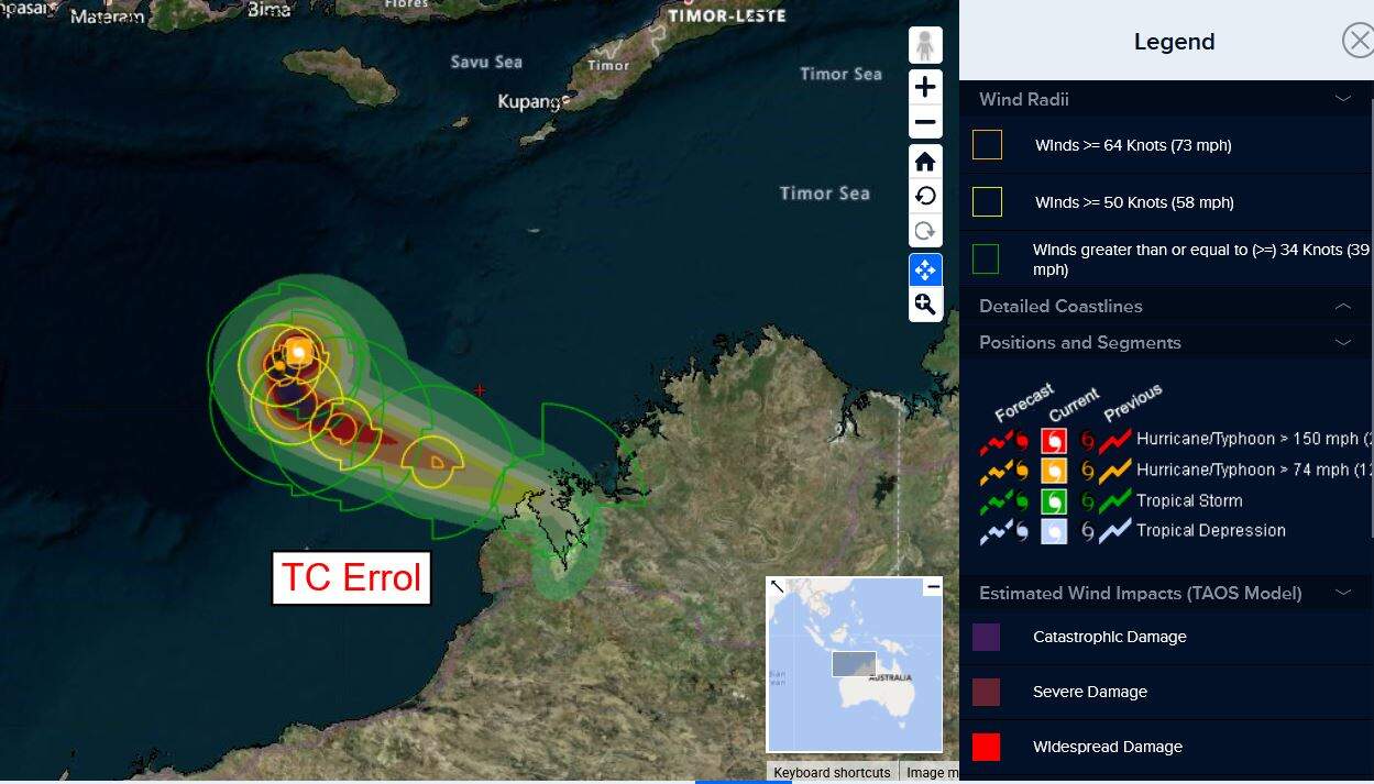
Errol
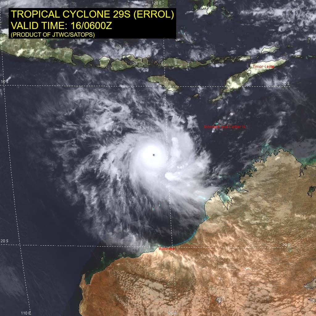
29S_160600sair
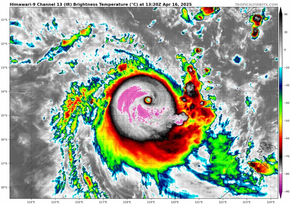
himawari9_ir_29S_202504161320_lat-14.4-lon118.9
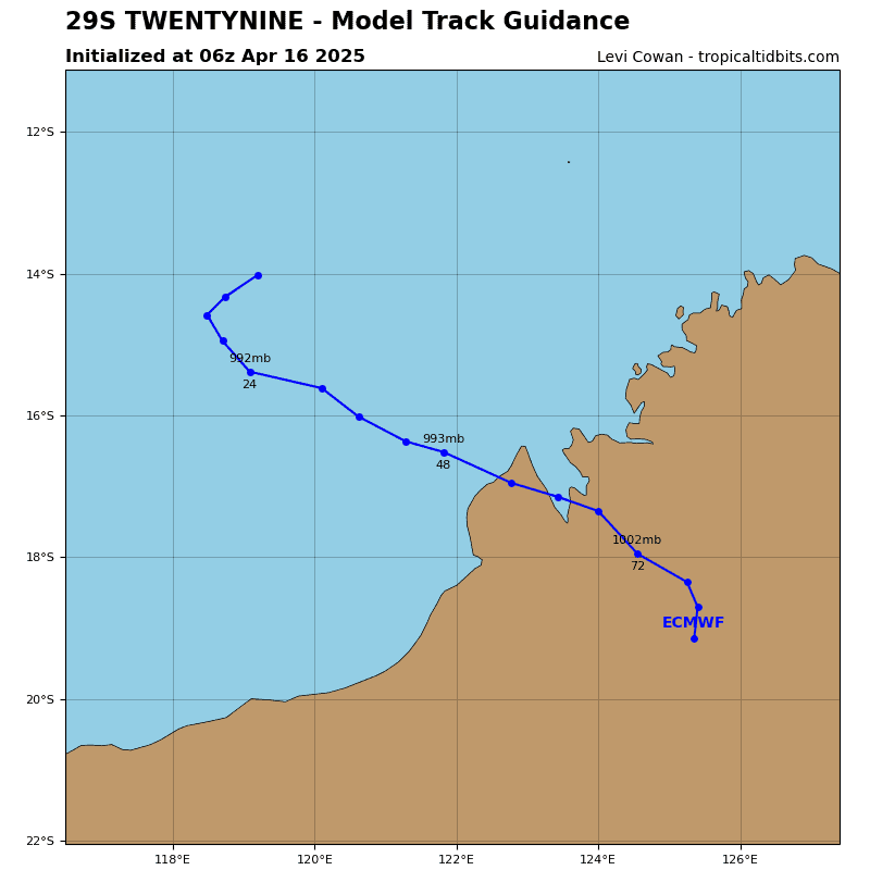
29S_tracks_latest
97p
himawari9_ir_97P_202504161320_lat-8.8-lon134.9
97P_tracks_latest
By PDC’s Senior Weather
Specialist Glenn James

The Pacific Disaster Center’s (PDC Global) Wednesday, April 16, 2025, Tropical Cyclone Activity Report…for the Pacific Ocean, the Indian Ocean, and adjacent Seas
Current Tropical Cyclones:
Tropical Cyclone 29S (Errol)…is located approximately 253 NM northwest of Broome, Australia
Northeast Pacific Ocean: There are no Tropical Cyclones
The last regularly scheduled Tropical Cyclone Activity Report of the 2024 eastern North Pacific Hurricane Season has been issued. Routine issuance of this section of the PDC product will resume on May 15, 2025. During the off-season, Special Tropical Weather Outlooks will be issued as conditions warrant by the NHC.
Central Pacific Ocean: There are no Tropical Cyclones
The 2024 central North Pacific hurricane season has ended. As such, the final routine Tropical Cyclone Activity Report for the 2024 season has been issued. Routine issuance of this section of the PDC product will resume on June 1, 2025. During the off-season, Special Tropical Weather Outlooks will be issued as conditions warrant by the CPHC.
Western Pacific, Indian Ocean, and adjacent Seas:
South Indian Ocean
Tropical Cyclone 29S (Errol)
According to the JTWC Warning number 22, sustained winds are 120 knots, with gusts to 145 knots.
Animated multi-spectral satellite imagery (msi) and animated enhanced infrared (eir) satellite imagery depict a pinhole, 7 NM wide eye feature, and a symmetrical central dense overcast (cdo). Cloud top temperatures have cooled, while the eye temperature has increased. TC 29S has put on an amazing show of explosive and extreme rapid intensification (eri), intensifying at least 60 knots over the past twelve hours. A microwave image reveals a compact microwave eye surrounded by deep convection and no real sign of a secondary eyewall, at least not yet.
The environment remains favorable for now, with warm sea surface temperatures, strong outflow aloft and low vertical wind shear.
As TC 29S (Errol) has undergone eri, it has also been slowing down and the newest frames of vis show the eye becoming quasi-stationary as the str to the south is already breaking down ahead of an approaching deep trough to the southwest. TC 29S thus appears to have already reached the inflection point in its track forecast and should meander slowly in a rather unpredictable fashion over the next few hours under weak steering
flow. A general turn towards the south should occur over the next 12 hours, then a sharp turn southeastward through 24 hours as the
system comes under the primary steering influence of the strengthening gradient between the trough to the southwest and a weak ridge to the northeast.
As the system steadily weakens after 24 hours, it will come under the steering influence of progressively lower levels of the atmosphere, though the deep-layer flow pattern remains generally westerly, which will help push TC 29S onto a east-southeastward track towards the coast of northwest Australia through 96 hours. Landfall northeast of Broome is expected by 72 hours, and as the system weakens below tropical storm strength, it will turn sharply southwestward along the western side of a developing low-level anticyclone over central Australia. Some models continue to show a sharper and earlier turn to the southwest, which would keep the system offshore while others track it straight inland, resulting in significant uncertainty in the later portion of the forecast.
Intensity-wise, the system will likely intensify a bit more, potentially reaching 130 knots by 12 hours. but the window of opportunity is very small, and mid-level shear picks up sharply as early as 18 hours, followed by a dramatic increase in deep-layer shear beginning at 24 hours. The system will become decapitated before 36 hours and rapidly weaken as it approaches the coast of Australia. Even if the system remains offshore, it will still weaken below ts strength within 96 hours.
Southwest Pacific Ocean
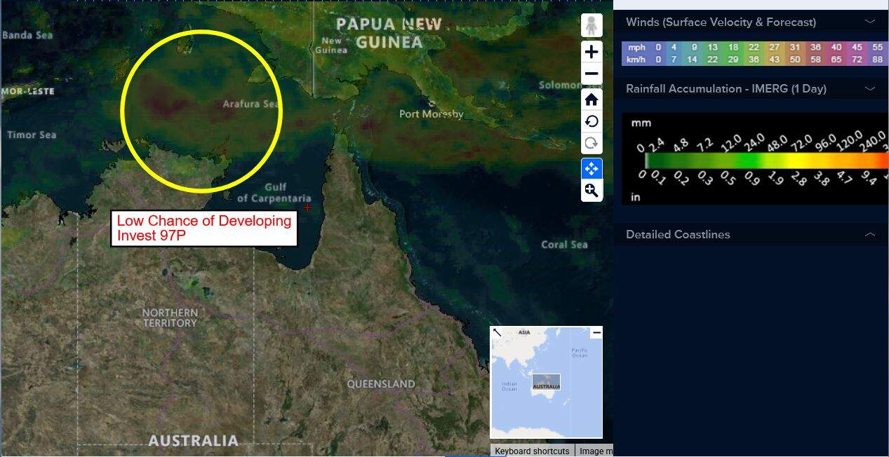
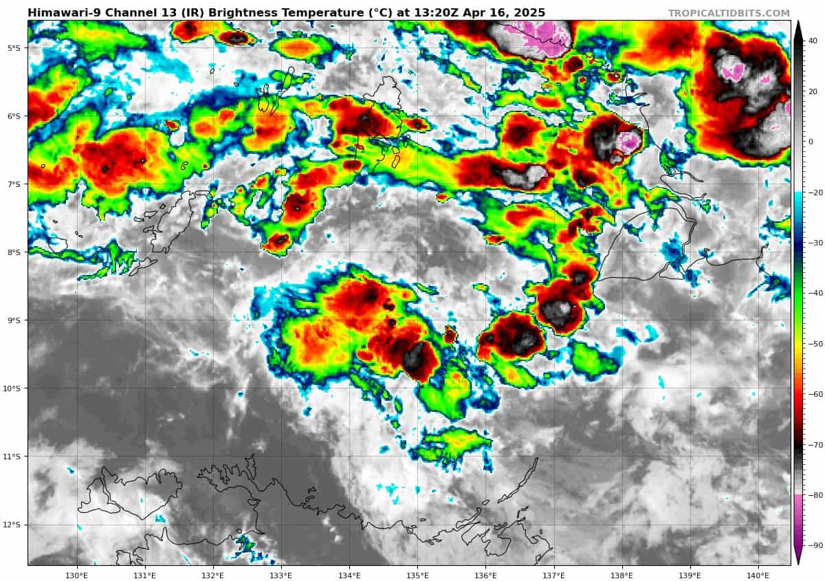
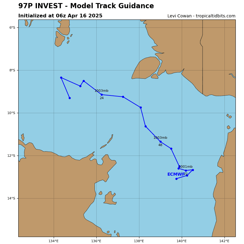
>>> An area of Disturbed weather being referred to as Invest 97P is located approximately 407 NM east-northeast of Darwin, Australia
Animated multi-spectral satellite (msi) imagery and a microwave image depict a slowly consolidating, partially exposed low level circulation center (llcc) with formative convective banding along the southern periphery of the llcc. A recent observation from Cape Wessel, Australia indicates sustained easterly winds of 19 knots.
Environmental analysis reveals a marginally favorable environment for development with low vertical wind shear (vws) of 10-15 knots, weak upper-level outflow and warm sea surface temperatures (sst).
Deterministic and ensemble models are in agreement, portraying slow development over the next 24 to 48 hours.
Maximum sustained surface winds are estimated at 20 to 25 knots.
The potential for the development of a significant tropical cyclone within the next 24 hours remains low.