

")
Current Snapshot
For all the latest updates visit: DisasterAWARE
zelia
17S_121200sair
14S_120600sair
himawari9_ir_16P
himawari9_ir_93W
93W_tracks_latest
By PDC’s Senior Weather
Specialist Glenn James

The Pacific Disaster Center’s (PDC Global) Wednesday, February 12, 2025, Tropical Cyclone Activity Report…for the Pacific Ocean, the Indian Ocean, and adjacent Seas
Current Tropical Cyclones:
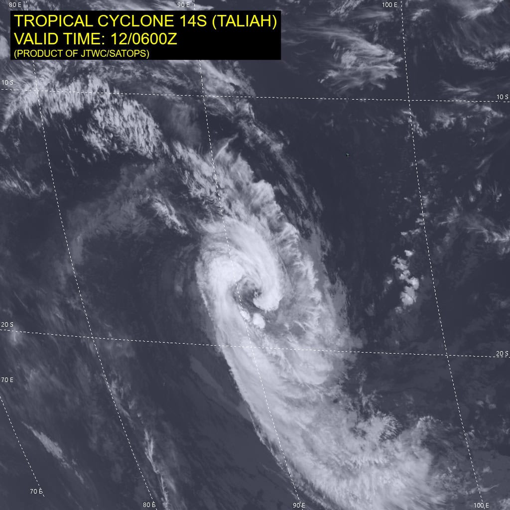
Tropical Cyclone 14S (Taliah) is located approximately 638 NM southwest of the Cocos Islands
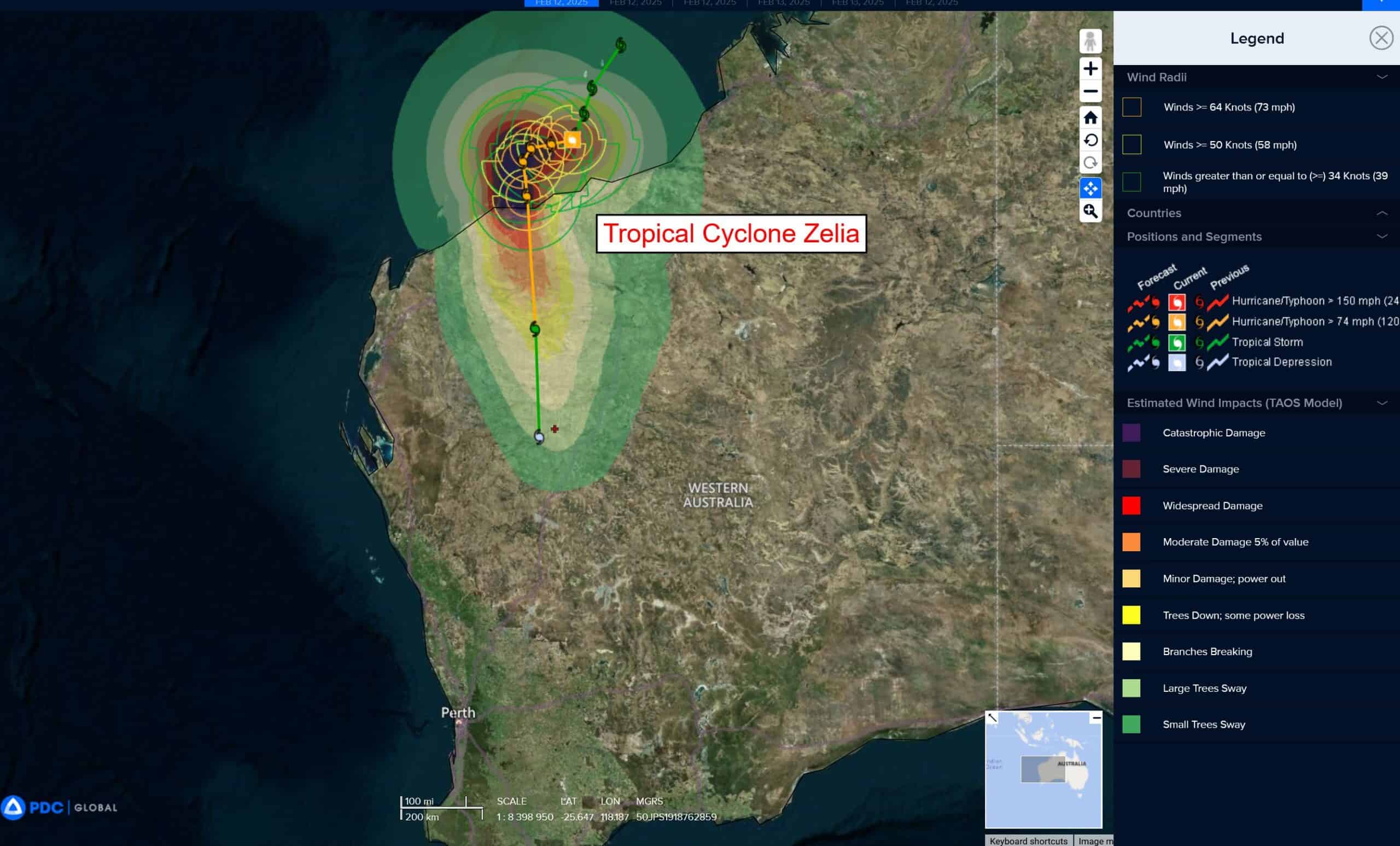
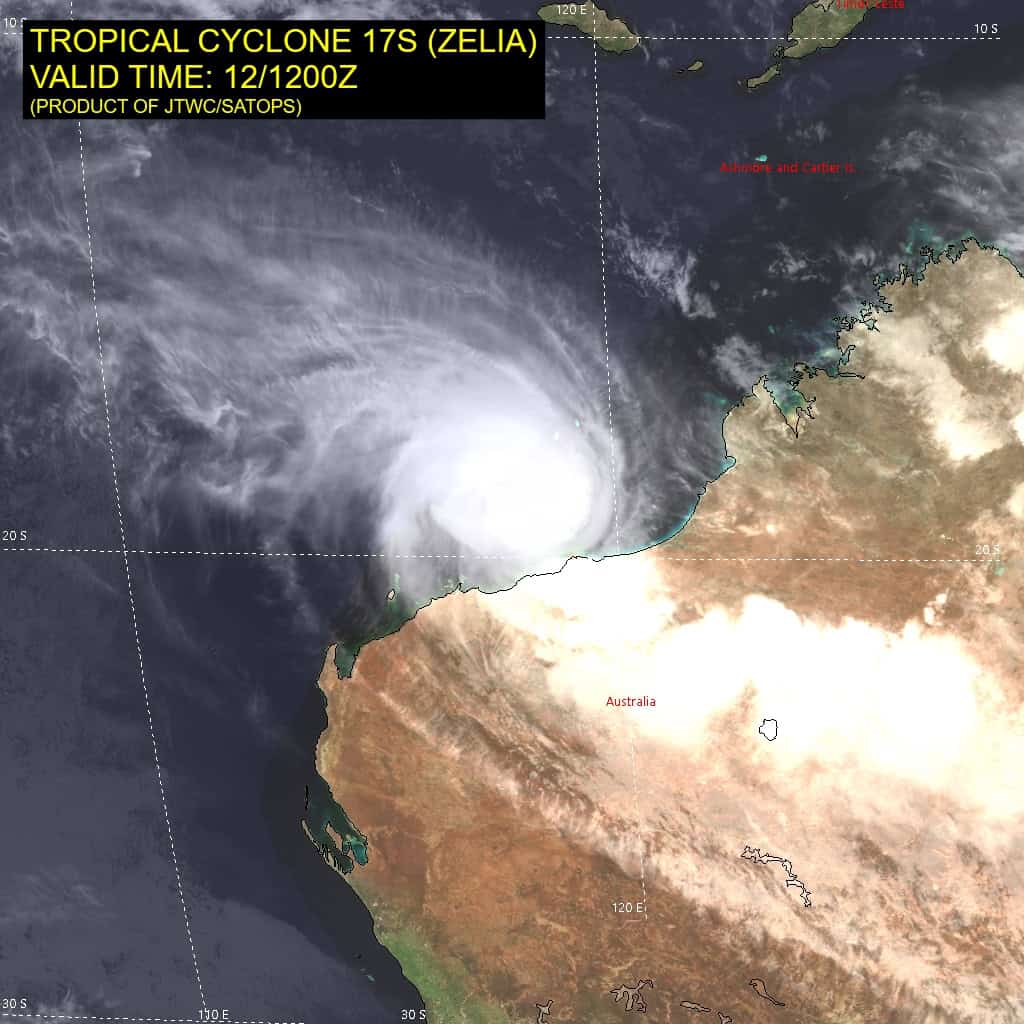
Tropical Cyclone 17S (Zelia) is located approximately 75 NM north-northwest of Port Hedland, Australia
Northeast Pacific Ocean: There are no Tropical Cyclones
The last regularly scheduled Tropical Cyclone Activity Report of the 2024 eastern North Pacific Hurricane Season has been issued. Routine issuance of this section of the PDC product will resume on May 15, 2025. During the off-season, Special Tropical Weather Outlooks will be issued as conditions warrant by the NHC.
Central Pacific Ocean: There are no Tropical Cyclones
The 2024 central North Pacific hurricane season has ended. As such, the final routine Tropical Cyclone Activity Report for the 2024 season has been issued. Routine issuance of this section of the PDC product will resume on June 1, 2025. During the off-season, Special Tropical Weather Outlooks will be issued as conditions warrant by the CPHC.
Western Pacific, Indian Ocean, and adjacent Seas:
South Indian Ocean
Tropical Cyclone 14S (Taliah)
According to the JTWC warning number 24, sustained winds were 65 knots with gusts to 80 knots
Animated multi-spectral satellite imagery (msi) depicts tropical cyclone 14S (Taliah) with a very large, ragged eye and a loosely defined eyewall. The system remains large overall and has yet to consolidate much.
Environmental analysis indicates that 14S is in a marginally favorable environment characterized by moderate poleward outflow, low (5-10 knot) vertical wind shear, and warm sea surface temperatures. TC 14S is forecast to continue tracking southwestward, along the str throughout the forecast period.
Regarding intensity, 14S is forecast to maintain intensity over the next 12 hours. After 12 hours, sea surface temperatures begin to drop, causing the system to weaken. Near 72 hours, poleward outflow is expected to improve, allowing 14S to maintain intensity though the remainder of the forecast period.
Tropical Cyclone 17S (Zelia)
According to the JTWC warning number 8, sustained winds were 120 knots with gusts to 145 knots
Animated multi-spectral satellite imagery (msi) depicts tropical cyclone 17S (Zelia) with a compact core of deep convection with a warm spot developing over the center, hinting at an eye beginning to form. Poleward outflow is robust, denoted by the defined cirrus filaments expanding outward from the system.
Environmental analysis indicates that 17S is in a highly favorable environment characterized by the strong poleward outflow, low (10-15 knot) vertical wind shear, and very warm sea surface temperatures.
TC 17S is forecast to track slowly west-southwestward through 36 hours as ridging from the west extends over to the south of the system. However, the steering pattern remains weak, so there is very high uncertainty regarding the track. After 36 hours, the ridge to the west will propagate westward and ridging over Australia will become the primary steering mechanism throughout the remainder of the forecast period.
This will cause the system to track generally southward as it makes landfall and tracks further inland. Landfall is currently forecast to occur near 60 hours, east of Dampier, but fluctuations in the landfall location are possible.
Regarding intensity, 17S is forecast to rapidly intensify over the next 48 hours to a peak of 120 knots in response to the continued highly favorable environment. After making landfall, terrain interaction will quickly erode the vortex, with dissipation forecast to occur near 96 hours.
Western Pacific Ocean
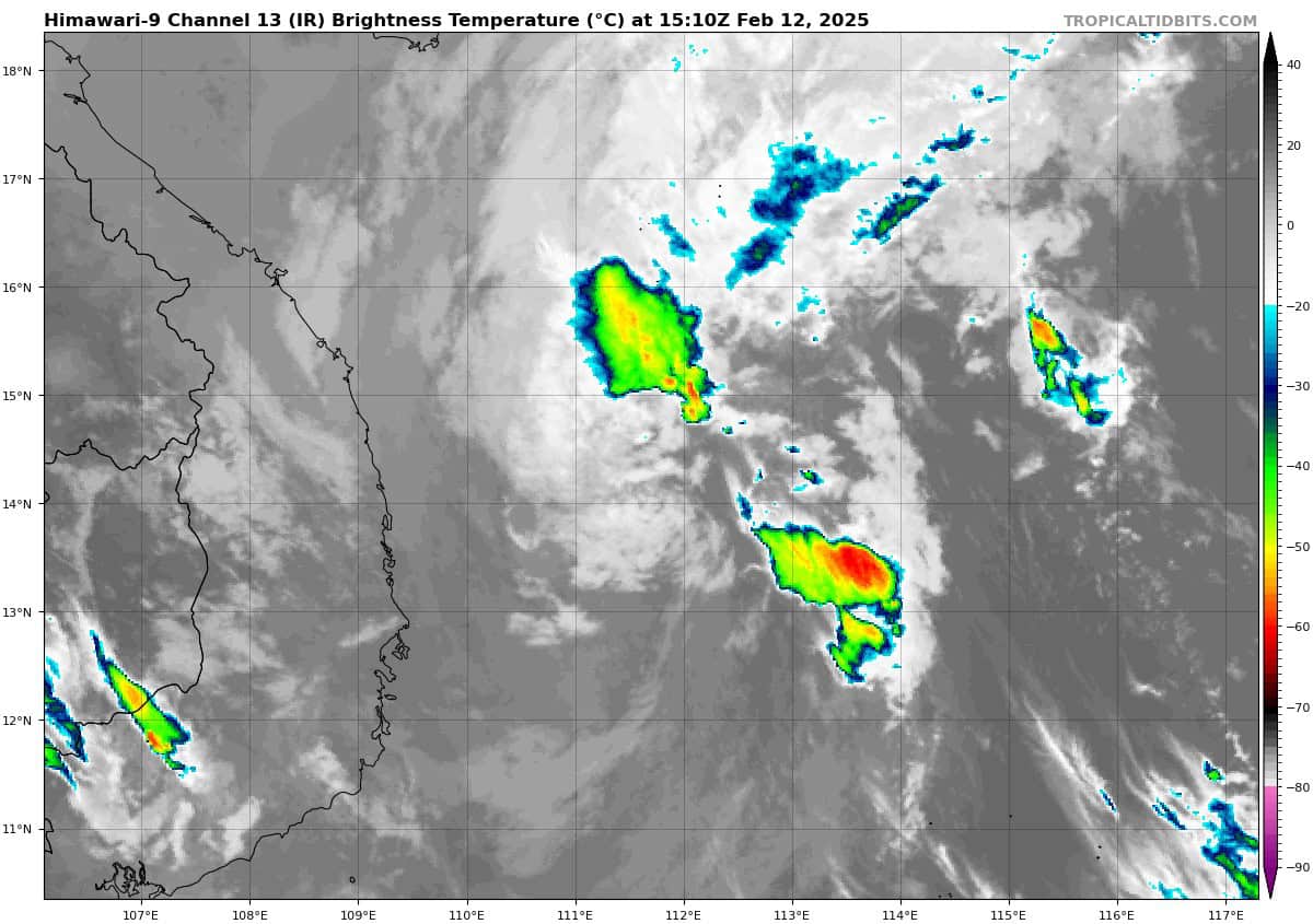
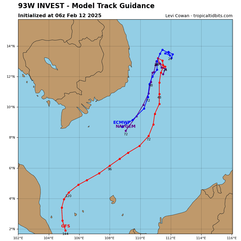
There’s an area of disturbed weather being referred to as Invest 93W, which is located approximately 307 NM northwest of Spratly Island
Animated visible imagery depicts a compact but disorganized llcc. Furthermore, a ascat metop-b image reveals enhanced northerly winds (15-20 knots) funneling along the coast of Vietnam but not yet turning east and wrapping into the circulation.
Environmental analysis reveals an unfavorable environment for further development with moderate to high (20-25 knots) vertical wind shear, moderate poleward outflow aloft, and marginal sea surface temperatures.
Global models are currently in agreement on a southerly track over with little development due to further increasing shear within the next 48 hours.
Maximum sustained surface winds are estimated at 13 to 18 knots.
The potential for the development of a significant tropical cyclone within the next 24 hours remains low.
Southwest Pacific Ocean
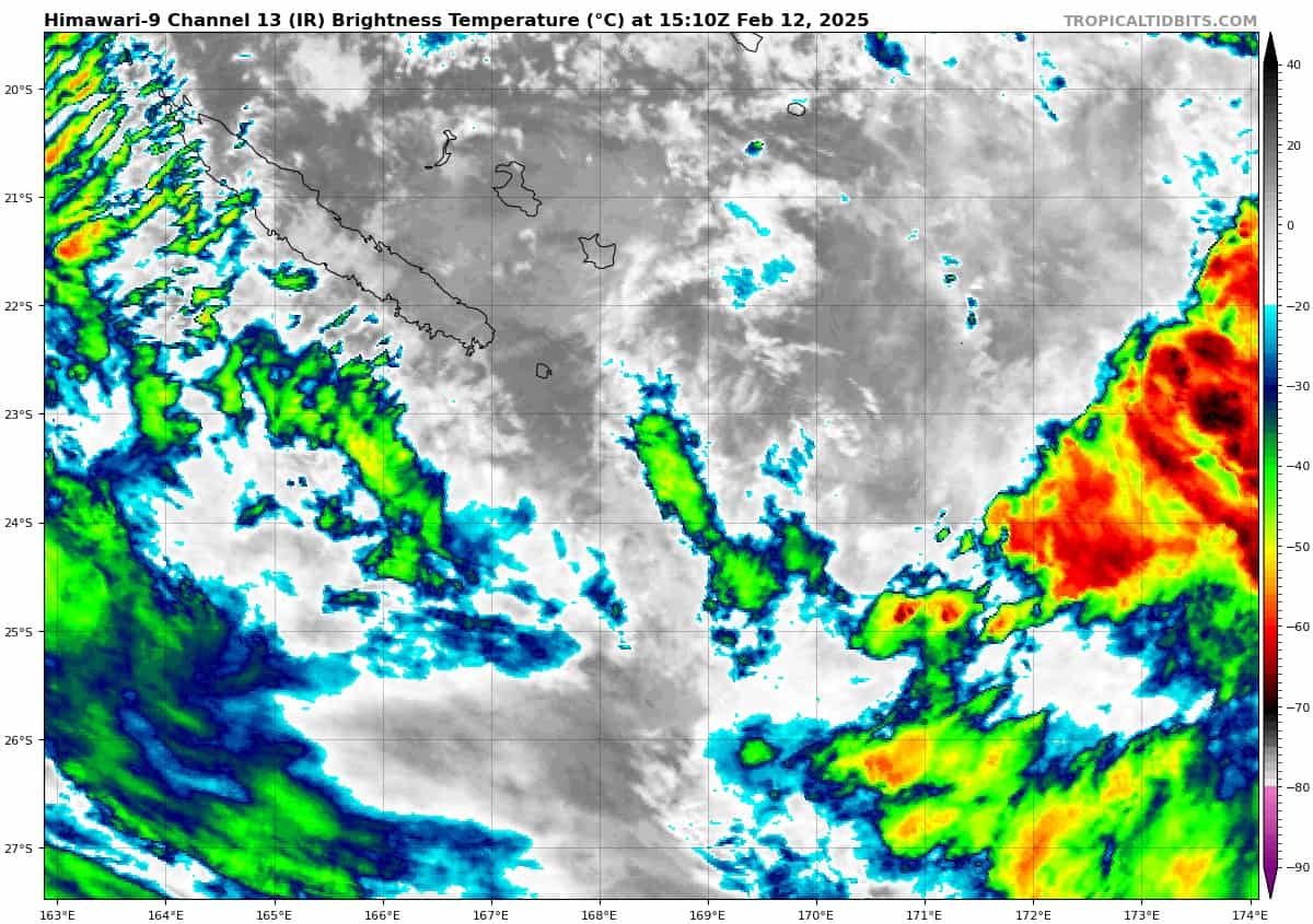
There’s an area of disturbed weather being referred to as the Remnants of 16P, which is located approximately 118 NM southeast of Noumea, New Caledonia
This system is currently classified as a subtropical cyclone, generally characterized as having both tropical and mid-latitude cyclone features.
Animated enhanced infrared imagery depicts a fully exposed low level circulation center (llcc) with convection that is being heavily sheared from the west. A ascat metop-b pass shows a belt of easterlies up to 35 knots within the
southern periphery of the system.
Environmental analysis indicates an unfavorable environment for tropical transition with a deep layer of dry air overtop the system, strong westerly flow aloft and borderline sea surface temperatures.
Global models are in agreement that the remnants of 16P will stay nearly quasi-stationary over the next 36 hours before getting sheared apart by an approaching long wave trough.
Maximum sustained surface winds are estimated at 30 to 35 knots.
The potential for the development of a significant tropical cyclone within the next 24 hours is low.