Current Snapshot
For all the latest updates visit: DisasterAWARE
By PDC’s Senior Weather
Specialist Glenn James

The Pacific Disaster Center’s (PDC Global) Tuesday, September 24, 2024, Tropical Cyclone Activity Report…for the Pacific Ocean, the Indian Ocean, and adjacent Seas
Current Tropical Cyclones:
Tropical Cyclone 18W, is located about 486 NM south-southwest of Yokosuka, Japan
Northeast Pacific Ocean:
>>> Offshore of Southern Mexico:
A trough of low pressure, partially associated with the remnants of John, is producing a large area of showers and thunderstorms along the coast of southern Mexico. Environmental conditions appear conducive for some development of this system and a tropical depression could form in the next couple of days or so, depending on if it stays over water. Interests in southern Mexico should monitor the progress of this system. Regardless of development, this system is expected to produce heavy rainfall with the potential for flash flooding and mudslides over portions of southern Mexico this week.
* Formation chance through 48 hours…medium…50 percent
* Formation chance through 7 days…medium…50 percent
Central Pacific Ocean: There are no Tropical Cyclones.
>>> Approximately 600 miles southeast of Hilo, Hawaii:
A trough of low pressure located far southeast of Hawaii is producing disorganized showers and thunderstorms. Development of this system is not expected as it moves westward at 5 to 10 mph.
* Formation chance through 48 hours…low…10 percent
* Formation chance through 7 days…low…10 percent
Western Pacific, Indian Ocean, and adjacent Seas:
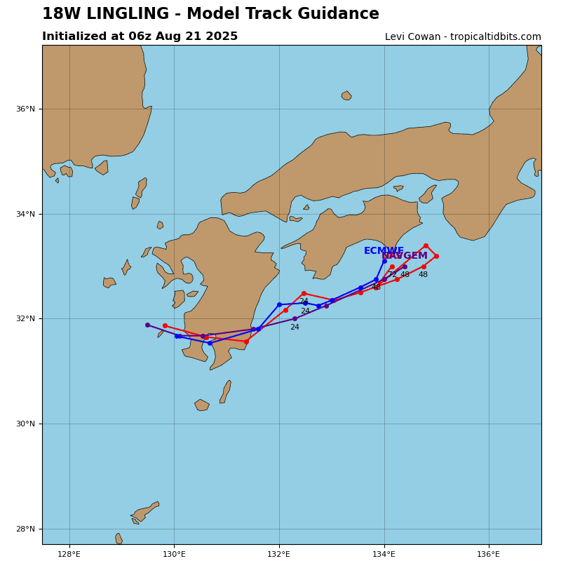
Tropical Cyclone 18W
According to the JTWC warning number 3, sustained winds were 30 knots, with gusts to 40 knots.
Animated enhanced infrared satellite imagery shows a small system trailing a cold front southeast of Japan that is struggling to consolidate under strong vertical wind shear as evidenced by its cold dense overcast offset eastward and mostly exposing the low level circulation (llc) once again.
Analysis indicates a marginal environment with warm sea surface temperatures, weak radial outflow, and moderate to strong vertical wind shear
The ridge to the east will become the predominant steering mechanism and drive the system northwestward. By 36 hours, it will crest the ridge axis then recurve and accelerate northeastward on the poleward side of the ridge.
The marginal environment will become unfavorable after 12 hours as the cyclone drifts into stronger vertical wind shear, eroding the system down to 25 knots. by 72 hours, TD 18W is expected to slightly re-intensify to 30 knots as the vertical wind shear relaxes.
Concurrently, it will also begin extra-tropical transition as it approaches the baroclinic zone, and by 96 hours, will transform into a cold core low. There is a distinct possibility that TD 18W will dissipate after 24 hours mostly due to the increased vertical wind shear.
>>> There’s an area of disturbed weather, being referred to as Invest 95W, which is located approximately 278 NM east of Guam
Enhanced infrared satellite imagery (eir) depicts a broad area of turning with flaring convection to the west that is being sheared from the northeast.
The environment is marginally favorable for development with warm, conducive sea surface temperatures and moderate equatorward outflow aloft. 95W is currently experiencing low shear (10-15 knots) in the upper levels, but is expected to move into an area of moderate shear (20-25 knots) as the system transits north-northwest.
Global models are in good agreement that the system will continue to track northwest with steady intensification over the next 12-36 hours.
Maximum sustained surface winds are estimated at 13 to 18 knots.
The potential for the development of a significant tropical cyclone
within the next 24 hours is low.


