

")
Tropical Cyclone 07E (Gilma) Tropical Cyclone 08E (Hector) / Tropical Cyclone 01C (Hone) / Tropical Cyclone 11W (Shanshan) / Invest 91A – Pacific
Tuesday, August 27, 2024
Current Snapshot
For all the latest updates visit: DisasterAWARE

pdchectortgilma

1800x1080epac

goes18gilma

144955_earliest_reasonable_toa_34gilma

07E_tracks_latestgilma

goes18hector

144808_earliest_reasonable_toa_34hector

08E_tracks_latesthector

pdchone

1200×1200

goeshone

144105_earliest_reasonable_toa_34hone

pdcshanshan
11W_271200sair

himawari9_ir_11W_202408271510_lat28.6-lon130.3

11W_tracks_latest

91a

meteosat9_ir_91A_202408272036_lat24.4-lon70.0

91A_tracks_latest
By PDC’s Senior Weather
Specialist Glenn James

The Pacific Disaster Center’s (PDC Global) Tuesday, August 27, 2024, Tropical Cyclone Activity Report…for the Pacific Ocean, the Indian Ocean, and adjacent Seas
Current Tropical Cyclones:
Tropical Cyclone 07E (Gilma)…is located about 775 miles east of Hilo, Hawaii
Tropical Cyclone 08E (Hector)…is located about 1400 miles west of the southern tip of Baja, California
Tropical Cyclone 01C (Hone)…is located about 505 miles west-southwest of Lihue, Hawaii
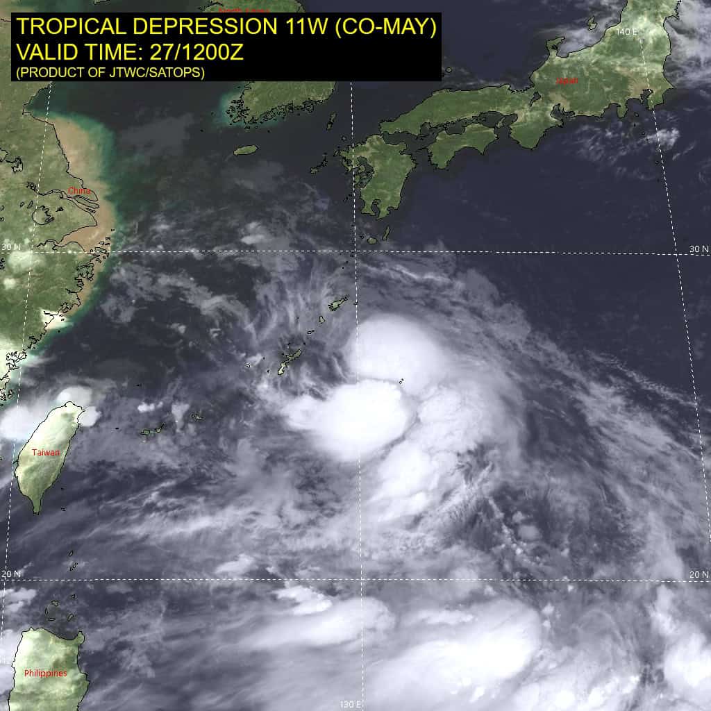
Tropical Cyclone 11W (Shanshan)…is located approximately 229 NM south of Sasebo, Japan
Northeast Pacific Ocean:
Tropical Cyclone 08E (Hector)
HECTOR FORECAST TO GRADUALLY WEAKEN OVER THE NEXT FEW DAYS
According to the NHC Advisory number 10
Hector is moving toward the west-northwest near 12 mph (19 km/h) and this motion with a turn more westward is anticipated over the next several days.
Maximum sustained winds are near 50 mph (85 km/h) with higher gusts.
Gradual weakening is anticipated during the next several days and Hector is forecast to become a post-tropical remnant low on Thursday.
Tropical-storm-force winds extend outward up to 70 miles (110 km) from the center.
Central North Pacific:
Tropical Cyclone 07E (Gilma)
GILMA STILL RAPIDLY WEAKENING
According to the NHC Advisory number 40
Gilma is moving toward the west near 13 mph (20 km/h). A motion between
west and west-northwest is expected for the next few days, and on the forecast track the remnants of Gilma should approach the Hawaiian Islands on Friday.
Maximum sustained winds have decreased to near 50 mph (85 km/h) with higher gusts. Continued steady to rapid weakening is expected, and Gilma is expected to weaken to a remnant low Thursday or Thursday night.
Tropical-storm-force winds extend outward up to 60 miles (95 km) from the center.
Tropical Cyclone 01C (Hone)
HONE CHANGING LITTLE IN STRENGTH AS IT MOVES WEST-NORTHWESTWARD
According to the CPHC Advisory number 23
Hone is moving toward the west-northwest near 10 mph (17 km/h), and a
westward to west-northwestward motion is expected for the next few days. On the forecast track, Hone will continue moving away from the main Hawaiian Islands, and pass well north of Johnston Island tonight and early Wednesday.
Maximum sustained winds are near 50 mph (85 km/h) with higher gusts.
Gradual weakening is expected during the next couple of days, and Hone is forecast to become a post-tropical low on Thursday.
Tropical-storm-force winds extend outward up to 80 miles (130 km) from the center.
Western Pacific, Indian Ocean and adjacent Seas:
Tropical Cyclone 11W (Shanshan)
According to the JTWC Warning number 27, sustained winds are 105 knots with gusts to near 130 knots
Typhoon (TY) 11W has completed an eyewall replacement cycle and has subsequently re-intensified slightly, with a 25-30 NM symmetric eye evident in animated enhanced infrared satellite imagery and radar imagery. Animated radar imagery also indicates a significant stall or slow northwestward drift near Kikai-jima, which reported maximum sustained northwesterly winds of 63.5 knots.
The system has remained resilient maintaining radial outflow, with robust equatorward outflow evident in the animated water vapor imagery, however, some flattening of the core convection due to northerly vertical wind shear is evident.
Typhoon Shanshan is tracking slowly along the western periphery of the ridge, toward a large break in the ridge associated with a major shortwave trough digging into the Sea of Japan. This trough is expected to rapidly fill and propagate eastward within the next day, with zonal mid-latitude flow forecast across North Korea and northern Japan through 120 hours. This will lead to unusually slow track speeds as the system tracks northward toward western Kyushu through 48 hours. Due to the slow track speeds, upwelling of cooler water is possible, which could contribute to additional weakening.
TY 11W is expected to maintain its intensity through 12 hours, with gradual weakening as the system approaches Kyushu due to increased friction and northerly vertical wind shear. After 48 hours, TY 11W should turn eastward to east-northeastward along the northwestern periphery of the ridge with rapid weakening and climatologically slow (6 knots) track speeds through 120 hours due to the aforementioned zonal mid-latitude flow displaced to the north. Additionally, there is a lack of a deep, dynamic mid-latitude major trough to produce a typical fast recurve track.
Rapid weakening is expected after the system makes landfall and tracks inland across the mountainous terrain of Kyushu, Shikoku and Honshu.
>>> There’s an area of disturbed weather in the Arabian Sea being referred to as Invest 91A…located approximately 189 NM east of Karachi, Pakistan
Enhanced infrared imagery depicts a broad but well-defined circulation with deep convection in the southwest quadrant. Scatterometery data shows offshore flow of westerly winds peaking at 25 knots.
91A is in a marginally favorable environment for development with good equatorward outflow, but its location is currently over land, hindering development.
models are in good agreement that 91A will track westward over the Arabian Sea during the next 48 hours, where warm sea surface temperatures and moderate vertical wind shear (15-20 knots) would
represent an overall favorable environment for development.
Maximum sustained surface winds are estimated at 28 to 33 knots.
The potential for the development of a significant tropical cyclone within the next 24 hours is upgraded to low.
